
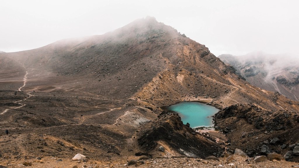
Few day walks anywhere carry a reputation like the Tongariro Alpine Crossing. In a single day you walk across an active volcanic landscape in the middle of New Zealand’s North Island, climb past a red crater that still steams, and drop beside lakes so bright they look painted. It is 19.4 km (12.1 miles) one way, and it asks more of you than the postcard suggests. Here is what we would tell a friend planning it for the first time.
The route and what it asks of your legs
The crossing runs from the Mangatepopo car park in the west (about 1,120 m or 3,675 ft) to the Ketetahi car park in the north (about 760 m or 2,490 ft). Nearly everyone walks it in that direction, because the climb is shorter that way. The first hour is gentle, following a stream up a valley to Soda Springs. Then the track climbs steeply up the Devil’s Staircase to the South Crater, a flat, pale floor that feels like walking across the moon.
From the South Crater the last real climb takes you up a ridge to the highest point of the walk at Red Crater, 1,886 m (6,188 ft). This is the section that catches people out. The ridge is narrow in places, the ground is loose scoria, and the wind can be brutal. On the far side, the descent to the Emerald Lakes is on steep, sliding volcanic gravel, and this is where most twisted ankles happen. Take it slowly and keep your weight back.
After the lakes the track crosses the Central Crater, climbs briefly past Blue Lake, then begins the long descent on the Ketetahi side. This second half is roughly 9 km (5.6 miles) of gradual downhill on a well-graded track, first across open tussock with huge views north to Lake Taupo, then through beech forest. Allow 7 to 8 hours in total, with a 6 hour finish only realistic for fit walkers on a clear day.
The mountains are sacred, and it matters
Tongariro National Park is a dual World Heritage site, recognised for both its natural and its cultural values. The peaks of Tongariro, Ngauruhoe and Ruapehu are sacred to the local iwi, the Maori tribes who gifted the mountain tops to the nation in 1887. Visitors are asked not to climb Ngauruhoe or Tongariro summit itself, not to touch or remove rocks, and not to enter the water of the Emerald Lakes or Blue Lake, which are tapu. We think of the crossing as walking through someone else’s cathedral: quietly, with respect, taking nothing but photographs.
Weather, gear and the alpine reality
The crossing is an alpine walk, even in summer. Conditions at Red Crater can be 10 degrees Celsius colder than at the car park, with winds strong enough to knock you off your feet. Snow can fall in any month. Between November and April, the track is usually snow free and the walk is a long but straightforward day for anyone with reasonable fitness. From May to October it becomes a winter alpine route with ice on the steep sections, and it should only be attempted with an ice axe, crampons and the skill to use them, or with a guide.
Whatever the season, we carry at least 2 litres of water each (there is no drinkable water on the track; the streams are volcanic and should not be drunk), a waterproof jacket and trousers, warm layers including hat and gloves, sun protection, and enough food for a full day plus a delay. Boots with ankle support are a real help on the scoria. If the forecast shows heavy rain, low cloud or high winds, the shuttle operators often cancel, and we treat that as good advice rather than an inconvenience.
Shuttles, parking and the booking system
Because the crossing is one way, transport is the first thing to sort out. The simplest approach is to book a shuttle from National Park village, Whakapapa or Turangi. Shuttles drop walkers at Mangatepopo early in the morning, usually between 6 and 8 am, and collect them at Ketetahi in the afternoon at agreed times. Parking at Mangatepopo is limited to a few hours, so leaving a car there for the whole day is not an option.
In recent years a free booking system has been introduced to manage numbers and protect the landscape. In general terms, walkers reserve a slot for their chosen date before setting out, and the shuttle companies check that reservation. Slots on fine summer weekends can go quickly, so we book as soon as our dates are firm and keep an eye on the forecast. The details of the system change from season to season, so check the official park information shortly before you go rather than relying on last year’s rules.
Hazards you should actually plan for
Tongariro is an active volcano. Te Maari crater, near the Ketetahi end, erupted in 2012, and the track passes through a marked hazard zone where you are asked to keep moving and not to stop for breaks. The risk on any given day is low, but it is real, and it is one more reason to check the current volcanic alert level before you walk. Beyond that, the main dangers are ordinary and predictable: hypothermia in bad weather, falls on the gravel descent from Red Crater, dehydration in summer sun, and simply running out of daylight.
Cell coverage is patchy but improving along the route, and there are toilets at the car parks, at Soda Springs, at the South Crater, near the Emerald Lakes and at the Ketetahi shelter site.
Making the most of it
Our best crossing days share a pattern. We book the earliest shuttle, walk the Devil’s Staircase in cool morning air, reach Red Crater before the wind gets up, and eat lunch beside the Emerald Lakes while the tour groups are still climbing behind us. A few things we always tell first timers, in no particular order:
- Book the shuttle and the walk slot together, and confirm the pickup time in writing.
- Check the forecast the night before and again at dawn; cancel without guilt if it is poor.
- Pack for winter in your bag even when you leave in a T-shirt.
- Poles make the scoria descent far kinder on the knees.
- Stay on the marked track everywhere; the ground beside it is fragile and, in places, unstable.
It is a long day, and a hard one in patches, but it is the kind of walk that stays with you for years. If you have one clear day on the North Island, this is how we would spend it.